×

|
Rate it:
Tags:
Level:
Length: 10 mi (16.1 km)
Surface: Singletrack
Configuration: Loop
Elevation: -
Total: 0 riders
Mountain Biking Whirinaki Forest Mountain Bike Track
#139 of 171 mountain bike trails in North Island
Here's how the Department of Conservation describes the trail:
"The Whirinaki Forest Mountain Bike Track is purpose built and weaves through one of the most spectacular and interesting forests in the world.
"The track is designed for the eco mountain bike rider and requires a medium fitness and skill level (grade 2 - 3). The track is 16 km and most people complete it in 2 - 4 hours. Shorter sections of the track can also be ridden."
First added by Jim Cummings on Nov 23, 2016. Last updated Sep 16, 2024. → add an update
Before you go
- Drinking water: unknown
- Lift service: unknown
- Night riding: unknown
- Pump track: unknown
- Restrooms: unknown
- Fat bike grooming: unknown
- E-bikes allowed: unknown
- Fee required: unknown
This trail information is user-generated. Help improve this information by suggesting a correction.
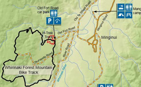
This trail is 90 km southeast of Rotorua, via SH38. Head for the village of Minginui which is 28km south of Murapara. The trail head at the end of old Fort Road.
