Yesterday was a rare "trail day" here at singletracks and despite the overcast and cool weather I managed to get out to two new trails in a single afternoon. One of the…
I took a trip to Europe recently and although I didn't get a chance to mountain bike while I was there, I thought perhaps writing about biking might allow me to write…
Mudhunny spotted an ad in Endurance magazine for North Carolina's first Trek concept store in Raleigh and since the trails were wet Saturday we decided to check it out. Before heading out…
Seattle area riders have found an overlooked urban location for new mountain bike trails: under the interstate. Collonade Park is located under I-5 and boasts trails built using thousands of volunteer hours…
Oops, looks like we just missed this one: The first mountain bike race on the Tamrang heritage trails in Rasuwa, Nepal. Why should mountain climbers be the only ones who get to…
If you're worried we've abandoned the blog thing, have no fear! After an international excursion, the singletracks blog will be back to daily updates starting next week. As it turns out French…
I used to tell beginner mountain bikers that they should attempt at least one new trick or obstacle each time they go out for a ride. For some people that means trying…
Women's mountain bike camps and clinics popping up all over the country. IMBA is teaming up with Dirt Series by Rocky Mountain bikes at two special camps in Hood River, OR and…
Movies about mountain biking are usually pretty predictable. Start with an interview/profile of a tatted up rider, show him/her do some gnarly jumps, and end with "outtakes" of said rider taking some…
Wow, what an awesome performance by the US women in the first round of this year's Mountain Bike World Cup. From usacycling.org: Led by Georgia Gould (Ketchum, Idaho/Luna), who placed eighth as…
I agree with Kevin on his thoughts on riding with dogs. I have an energetic 95 lb shepard-lab mix, Jackson, as my running buddy (personal trainer might be more appropriate) but I…
If you're a gamer wanna-be but would rather spend $300 on bike bling than on a wii, check out this free mountain bike video game. It's full of precarious drops and tricks,…
I added Douthat State Park in Virginia to my trail wishlist about two years ago when a friend said the trails there were better than Tsali. The Mountain Bike Virginia Falconguide seemed…
Good article on the Julian 7500 Death March endurance mountain bike race in San Diego County last month. Only 12 of the 38 who started the race finished it and one racer…
This is probably old news by now but it looks like Floyd Landis will be riding his mountain bike at the Teva Mountain Games in Vail June 2-3. Landis will be competing…
Picture this: You're riding your mountain bike down a remote section of trail when suddenly, out of nowhere, a mountain lion starts to chase you. You pedal faster and faster but the…
For once mountain bikers are on the other side of the trail access debate. Apparently mountain bikers are fed up with equestrians illegally using the trails at two parks in the Lubbock,…
I've been a Garmin guy ever since I got my first GPS for Christmas in 2000. I'm on my fifth Garmin GPS now (the latest: Garmin Edge 305 which is sweet by…
Whistler Resort is putting on the Crankworx freeride mountain bike festival at Winter Park in Colorado this summer. The legendary Crankworx festival is held in Whistler, British Columbia each year and features…
For those who have dreamed of riding the famed Kokopelli Trail but haven't had the time to plan the trip, Bikerpelli 2007 might be a good option for you. The 5th annual…
Trail users often use the phrase "illegal trail" to describe a number of mountain bike trail situations, some more illegal than others. Some trails are located in designated wilderness or Federally managed…
KLUNKERZ will screen at the Newport Beach Film Festival at the Edwards Island Cinemas on April 22nd at 3:30 pm. The film is about a group of friends in Marin County whose…
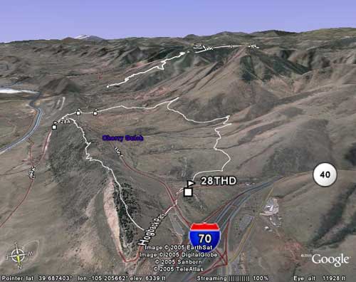
Over the past year we've looked at a ton of GPS mountain bike trail data from all over the country and we started noticing a pattern: many of you are using TopoFusion…
Nope, this isn't about Ray's MTB Indoor Park in Cleveland - it's the Red Bull Ride the Sky 2007 from St. Paul, MN. If you haven't heard St. Paul has this crazy…
Good chance for Oregon mountain bikers to advocate for some new and improved mountain bike trails in Silver Falls State Park. The park recently added about 350 acres and park managers are…
Ron Rash had a great piece in the Aspen Times a couple weeks ago about mountain bike performance anxiety. Really, Ron is talking about the mental part of mountain biking - you…
I had hoped to get off the trail access topic for today's post but it seems like it's the only mountain bike news getting any press lately. The New England Mountain Bike…
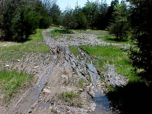
Let's be honest: Mountain bikes cause erosion - but then again, so do hikers, horses (big time), and certainly ATVs. Heck, even wild animals like deer are known to leave trails in…
If you're a GPS mountain biker and you use an Apple Computer, you've been left out in the cold by many of the popular GPS software programs. Fortunately Google Earth for Mac…
Hikers and equestrians offer a number of reasons for why mountain bikers shouldn't be allowed to use certain trails but perhaps their most compelling arguments center around safety concerns. I'm sure most…
A little known feature of Google Earth is the ability to use custom map overalays. Several people have found ways to use topographic maps as Google Earth overlays and the Google Earth…
I have some good news and bad news to report regarding mountain bike trails - which do you want first? Bad news? Okay, let's get it out of the way. Hikers and…
I'm selling my beloved (and gently used) Garmin Edge 205 GPS on eBay and I'm throwing in a free 1-year full access singletracks membership to the winning bidder. If you've read my…
We finally sent our first email newsletter to singletracks members yesterday afternoon and the response has been great so far. To get the newsletter you need to have 1. signed up for…
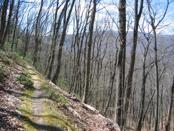
Edward McIlvain posted a convincing column yesterday over at YourHub.com about riding on wet mountain bike trails in the Golden/Denver area. I'm certainly guilty of trying to get out too early after…
Learning to track stand on your mountain or road bike takes practice and it's tough for most people to hold steady for more than a few seconds. One rider in Oregon, however,…
If you're a regular reader of this blog you'll remember that just 2 weeks ago I posted a glowing review of the Garmin Edge 205. I was so smitten, in fact, that…
Poison Oak Productions has produced an excellent documentary called Singletrack MINDS that takes a look at trail access issues in Marin County, California, the birthplace of mountain biking. I had a chance…
The Glenwood Springs Post Independent had an interesting article (registration required) last week about high school students from Carbondale learning to build bike frames from master frame builder Koichi Yamaguchi. Yamaguchi has…
Editor's note: This review was first posted in August of 2005 on our sister blog at TripleBlaze.com and has been updated with mountain bike specific information. I purchased a Garmin Forerunner 201…
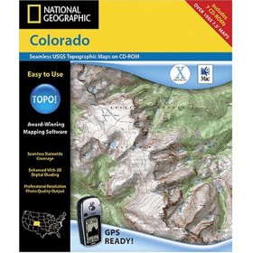
I was all set to write a thoughtful review of National Geographic's TOPO! software for mapping GPS data but after much frustration, I give up. Okay, I don't completely give up, but…
Seems like these days most mountain bike training focuses on improving physical endurance, but few take the time to teach technical skills. Most people are either just born athletes or they spend…
The Presidents of the USA song "Cleveland Rocks" was once just a sarcastic jab at the Forest City but it now looks like Cleveland may actually rock some midtown mountain bike trails…
For years mountain bike manufacturers have been sponsoring elite level riders as a way of promoting their brands. Everyone knows Lance rode a Trek so that makes Trek bikes cool. But does…
What has four mountain bike tires, disc brakes, no gears, and no pedals? Nope, it's not the pile of cannibalized bikes in your tool shed, it's the R-one 4x4 - the raddest…
Graham at Go Clipless posted recently about capturing flow in mountain bike photography and since I read his post I've been on the lookout for good examples, particularly in MTB videos. The…
If you haven't heard, there are some guys that are attempting to ride their mountain bikes from Alaska to the tip of South America and according to the blog they're down in…
It seems like there was something like this available before but apparently Shimano's "Coasting" technology is news worthy enough for CNET this week. The technology uses a computer chip to control automatic…


 4
4