Jeff Barber

Jeff co-founded Singletracks with his wife Leah in 1998 and has been dedicated to sharing the mountain bike information that inspires others to take epic adventures ever since. He started mountain biking in high school and served in the US Air Force before devoting himself full time to Singletracks in 2007.

Though formally educated as an engineer, Jeff began writing stories at an early stage, inspired by his mother who is a longtime accomplished author. He enjoys covering the world of mountain biking from every possible angle, whether it's trails or gear or skills. His goal for every story: that readers learn at least one new thing.

Author snapshot

MTB Background and expertise

  • Riding experience: Trail, XC, and bikepacking.
  • Mountain biking since: 1992
  • Number of products reviewed: ?. I think my first product review for the site was this one for a plastic wallet.
  • Current stable: Canyon Neuron, Orange P7 hardtail, and Scott Fun XC

Education and writing experience

  • Bachelors of Science in Engineering, Duke University
  • Masters of Business Administration, Duke University
  • Other publications: Panther Press (Lakeside High School - Augusta, GA), CitySearch.com
 
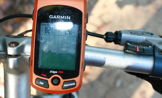
A close-up view of a Garmin Edge 705 cycling computer mounted on a bike handlebar, displaying an elevation reading of 821 feet. The screen shows a graphical representation of the terrain. The bike's handlebar and gear shift are also visible in the image.
  1
A silver bicycle decorated with a large red bow stands next to a Christmas tree adorned with blue and gold ornaments. The scene is set in a cozy room with wooden floors and a patterned rug.
  1
Two Blackburn bicycle pumps resting on a bed of dry, fallen leaves. The pumps are black with silver detailing, showcasing the Blackburn logo prominently. One pump is partially extended, while the other is fully collapsed. The autumn leaves in the background provide a natural setting.
  2
A cyclist in a black outfit and race number 59 loses control and falls in a snowy landscape, with a bike flipping in the air. Red and white tape marks the course in the background against a clear blue sky.
A decorative wall piece featuring an abstract relief sculpture of a cyclist, framed within a rectangular shape, set against an oval textured background. The sculpture has metallic tones, highlighting the figure in motion.
  1
Promotional image for Ellsworth Bikes offering a $250 discount on USA-made bicycles for the holiday season. The image includes several pieces of text detailing the promotion, instructions for redeeming the offer, and a certificate for the discount. The layout features a header with the Ellsworth logo, a festive message, and a call to action encouraging customers to take advantage of the deal.
  1
A close-up view of a muddy bicycle, focusing on the saddle and rear frame, with a blue sky and fluffy clouds in the background.
  3
A holiday gift guide for mountain biking enthusiasts, featuring a selection of products organized by price categories: under $25, under $50, and under $100. Items include clothing, accessories, and gear such as a bike T-shirt, tires, tools, apparel, and hydration packs. The guide is designed for easy navigation, with images and brief descriptions for each item.
A Garmin Edge 305 cycling computer displaying elapsed time, distance, and speed is shown alongside a map and elevation profile of a cycling route. Below, there is a table listing two activities, including the dates, locations, types of activities (mountain biking and running), distances, average speeds, and corresponding times.
A black mountain bike with a sleek frame, front suspension fork, and disc brakes. The bike features wide tires suitable for off-road trails and a modern design ideal for mountain biking enthusiasts.
  1
Map of Cochran Shoals, Sope Creek, and Powers Island within the Chattahoochee River National Recreation Area in Atlanta, Georgia. The map highlights various trails, including biking trails marked in red, as well as areas for pedestrians, parking, and other facilities. The legend provides information on trail difficulty and usage restrictions.
  2
Close-up image of a black mesh fabric featuring round, padded sections. The fabric is characterized by a series of circular cutouts that allow for ventilation, and the padded sections are designed in contrasting colors. The material also includes decorative stripes along the edges.
  1
Poster for the 5th Annual Le Tour de Tryptophan event, featuring decorative swirls and elegant typography. The event details include "24 Hours of the Fullerton Loop," scheduled for November 28-29, 2008, with activities from Friday noon to Saturday noon. It is organized to benefit the So Cal Interscholastic Cycling League, with a $30 donation suggested. Additional notes mention the meeting location at the Upper Lot of the Fullerton Courthouse and state that it is a non-event with no insurance or guarantees, encouraging participants to enjoy the experience.
Alt text: A promotional flyer for the Winter Holiday Shootout Series at Vail Lake Resort in Temecula, California. The flyer includes event details: race dates on November 8, November 29, and January 3, registration information, an entry fee of $35, and mentions a chance to win a Cannondale mountain bike. Logos of sponsors are also displayed.
A wooded area with a wooden ramp leading down to a dirt bike track. A warning sign is visible on a tree, and a group of cyclists is gathered at the base of the ramp near the track. The scene is surrounded by trees, with a rocky hillside in the background.
  2
Two mountain bikes are displayed side by side, both featuring an olive green frame. The bike on the left showcases a classic design with a prominent suspension system, while the bike on the right has a more modern frame and streamlined features. Both bikes are equipped with thick, rugged tires suitable for off-road terrain.
  2
A mountain bike featuring a bronze-colored aluminum frame, front suspension fork, and knobby tires suitable for off-road terrain. The bike is shown from a side angle, displaying its gear system and disc brakes.
  2
A close-up of a person smiling while holding a hand of playing cards, showing an Ace, King, and a pair of eights in hearts, with a blurred natural background.
A bright green bicycle frame with a distinctive design, featuring a rear shock absorber and branded with the name "Morewood." The frame is angled to highlight its structure against a gradient black background.
  1
Two SRAM double-tap shifters in silver with black accents, featuring a curved lever design, displayed on a counter. Cables are attached, and part of a bicycle component is visible in the foreground.
A group of mountain bikers competing in a race, captured in motion as they accelerate across a grassy field. Several participants are wearing colorful jerseys and helmets, with numbers displayed on their bikes. Spectators can be seen in the background, watching the race. Trees line the background, suggesting an outdoor event.
A man wearing a black 'LIVESTRONG' t-shirt with a yellow logo, looking slightly to the side with a focused expression. The background is plain and uncluttered.
A streamlined, futuristic vehicle speeding along a deserted road with mountains in the background, showcasing a vast, open landscape. The vehicle features a smooth, aerodynamic design with a white upper half and a black lower half, suggesting a focus on efficiency and speed.
  1
A mountain biker riding through a lush green meadow, with a background of tall trees and snow-capped mountains under a clear blue sky.
A dog wearing a black helmet, showcasing its profile and floppy ears.
A group of cyclists and spectators gathered at a mountainous location, with some individuals holding a banner that reads "Powered by Chipotle." The scene captures the enthusiasm of cycling fans, with colorful flags and team jerseys visible, as they cheer on participants in a cycling event.
  1
Map of the Chattahoochee River National Recreation Area, showing marked trails, scenic areas, and surrounding roads. The map highlights various points of interest and includes symbols for amenities and features within the area.
  2
A silhouette of a person riding a bicycle on a hill against a backdrop of a dusk sky filled with soft clouds and tree outlines.
  1
Image of two mountain bikes side by side on a white background. The left bike has a more robust frame and thicker tires, while the right bike is sleeker with narrow tires. Above the bikes, there is a green map outline of the United States.
  6
A humorous illustration comparing four political figures to different types of bicycles, with each figure accompanied by a bike that symbolically represents them. The top features one figure pairing with a red road bike, the second with a black commuter bike, the third with a vintage penny-farthing, and the fourth with a children's tricycle.
Aerial view of a tranquil lake surrounded by lush green forests, with a sandy beach and boats along the shore. The scene captures the clear blue water transitioning to lighter shades near the shoreline, framed by rocky outcrops in the foreground.
  1
Two mountain bikers navigate a dirt track during a competitive race. One rider, wearing a blue helmet and black and yellow gear, leans into a turn, kicking up dust, while the other biker, dressed in black and white, closely trails behind. Spectators can be seen in the background, enjoying the event under a clear blue sky.
A sleek, minimalist bicycle with a shiny gold frame, featuring a brown leather saddle and handlebars. The wheels have striking gold accents, set against a dark background that highlights the bicycle's design and elegant curves.
A mountain bike race scene featuring two cyclists navigating a turn. One cyclist in a blue jersey and helmet is leading, while another in a red and white jersey trails closely behind. Spectators are on the sidelines, including a woman taking a photo. The background shows a blue sky and a fence with a Hyundai advertisement.
  1
<!-- wp:image {"id":1490,"linkDestination":"custom"} -->
<figure class="wp-block-image"><a href="https://www.singletracks.com/wp-content/uploads/2008/12/garmin-edge-705.jpg"><img src="https://www.singletracks.com/wp-content/uploads/2008/12/garmin-edge-705.jpg" alt="" class="wp-image-1490" title="garmin-edge-705"/></a></figure>
<!-- /wp:image -->

<!-- wp:paragraph -->
<p></p>
<!-- /wp:paragraph -->

<!-- wp:paragraph -->
<p>The <a href="http://www.singletracks.com/mtbreviews/Garmin/Edge-705/602.html">Edge 705 cycling GPS</a> from Garmin promises it all: detailed, full color, road and topo maps; accessories for intense ride data collection; navigation and directions; ride elevation profiles; and much more. But does the device live up to the hype? We decided to test it the only place it all matters: on the mountain bike trail.</p>
<!-- /wp:paragraph -->

<!-- wp:paragraph -->
<p><strong>Design</strong></p>
<!-- /wp:paragraph -->

<!-- wp:paragraph -->
<p>The small size and shape of the Edge 705 make it the perfect GPS for mounting on your handlebars. The quick mount system allows you to clip and unclip your GPS yet still keeps the unit safe and secure on washboard trails. Reading the Edge 705 in glaring sunlight is no problem thanks to the brilliant 2.2" diagonal color display and there's even a backlight for epic rides that go a little longer than expected. The new Team Garmin-Chipotle colors should have fans excited but unless you already have an orange or blue bike I say stick with the plain black original.</p>
<!-- /wp:paragraph -->

<!-- wp:paragraph -->
<p><strong>Loading detailed base maps</strong></p>
<!-- /wp:paragraph -->

<!-- wp:paragraph -->
<p>Before you can head out to the trail you'll need to load up the Edge 705 with detailed maps of the area you'll be riding. Two things you need to know:</p>
<!-- /wp:paragraph -->

<!-- wp:paragraph -->
<p>1. Detailed maps are NOT included with the Edge 705. If you're riding on the road and want Tom Tom-style turn-by-turn directions and navigation, you'll need Garmin MapSource City Navigator software (about $100). For trail riding I recommend Garmin MapSource Topo (also about $100). MapSource Topo won't allow you to create point-to-point directions on your GPS like City Navigator but it does include detailed road maps to help you get oriented. Sounds confusing, huh? Unfortunately it is.</p>
<!-- /wp:paragraph -->

<!-- wp:paragraph -->
<p>2. You can't fit maps of the entire US on your device at once. This may not seem like a big deal since most riders stick to trails within their state or region but if you're planning that big trip out to Moab, be sure to load the detailed basemaps up before you head out! Believe me, I speak from experience here.</p>
<!-- /wp:paragraph -->

<!-- wp:paragraph -->
<p>The distinction between base maps and trail maps on a GPS may seem strange to first-time users so here's one way to think about it: base maps are like your old paper folding maps with roads and official points of interest marked. You can't edit the map since it's already printed but you can ADD to the map with your own hand-drawn lines and labeled points of interest. The drawn lines in this example are called "tracks" on a GPS while the labeled points are called "waypoints." All of this is to say: now that you have your base maps loaded, it's time to get a trail (track) to follow.</p>
<!-- /wp:paragraph -->

<!-- wp:paragraph -->
<p><strong>Loading trails (tracks)</strong></p>
<!-- /wp:paragraph -->

<!-- wp:paragraph -->
<p>The Edge 705 makes it easy to load tracks from you computer and there are actually a few ways to do this. If you're using MapSource or Garmin Training Center software, simply select the track and choose "Send to Device." Otherwise, just plug the Edge 705 into your computer's USB port and your computer will usually recognize the GPS as a data drive (even on a Mac!). Just drag track files to the GPX folder and that's it! Both of these methods work great for <a href="http://www.singletracks.com/mountain-bike/map-list.php">trail files</a> downloaded from singletracks - sweet.</p>
<!-- /wp:paragraph -->

<!-- wp:paragraph -->
<p>The Edge 705 also allows you to wirelessly exchange trail data with other Edge 705 users via the built-in ANT+ wireless technology. Though I didn't get a chance to try this feature out, it appears to be pretty straightforward and can be a good way to swap epic routes with mountain bikers you meet on the trail.</p>
<!-- /wp:paragraph -->

<!-- wp:paragraph -->
<p><strong>Following trails</strong></p>
<!-- /wp:paragraph -->

<!-- wp:paragraph -->
<p>The Edge 705 does a great job at helping you follow trails you've loaded via computer or wirelessly. Of course you can follow the map visually but that's usually tough to do on tight, technical trails that require your undivided attention. So, in addition to on screen cues and the map itself, the Edge 705 can be configured to beep when you're approaching a turn or intersection to get you attention. In our tests this worked pretty well, though on super twisty trail sections the beeping got a little annoying, especially when there was only a single, obvious trail to follow.</p>
<!-- /wp:paragraph -->

<!-- wp:paragraph -->
<p><strong>Other features</strong></p>
<!-- /wp:paragraph -->

<!-- wp:paragraph -->
<p>Road cyclists clearly had a big influence on the design of the Edge 705 and that influence really shows in the accessories line-up from Garmin. The heart rate monitor felt comfortable and syncs quickly with the GPS. Other accessories like cadence and power meters are mostly worthless to mountain bikers (unless you're stuck inside on a trainer) and fortunately the base Edge 705 package leaves these doo-dads out. Hopefully in the future we'll see MTB-specific accessories that use the ANT+ system (G-shock impact meter or a hang time calculator perhaps?).</p>
<!-- /wp:paragraph -->

<!-- wp:paragraph -->
<p>The Garmin Edge 705 is a whole lotta GPS in a small package and the best part is you can just set it and forget it most of the time. It's a great choice for trail navigation and MTB training data collection - just remember to look away from the screen every now and then when you're on the trail ;)</p>
<!-- /wp:paragraph -->
  1
A sleek, modern mountain bike featuring a black and red frame, front suspension, and advanced gear components. The bike is positioned against a plain white background, highlighting its design and features.
Image alt tag: A promotional poster for the Pixie Cross World Championship featuring two cyclists racing on 16-inch bicycles in a colorful, lively environment. The poster includes event details such as the date (Saturday, July 12th), location (Downtown Downieville, next to the fire station), and a description of the open class event. Graphics include the WTB logo and striking typography.
  2
A cyclist sitting on a folding chair in a natural outdoor setting, with a mountain bike leaning against the chair. The cyclist, wearing a colorful biking outfit, appears contemplative as the sun sets in the background, illuminating the surrounding landscape.
  2
A group of four mountain bikers wearing helmets and numbered jerseys ride along a dirt trail through a grassy field, with spectators in the background. The scene captures a competitive cycling event, showcasing the riders focused on their performance.
A mountain biker in a blue and black outfit stands next to a white 2009 GT Avalanche 1.0 bike, while another cyclist in an athletic outfit sits on the ground in a wooded area. The scene depicts a trail with greenery surrounding them.
  1
A mountain biker in a red and white jersey rides through a rocky terrain at night, illuminated by bike lights. The image features the text "24 Hours of Moab" and mentions the race's significant cash prizes, celebrating its 13th year.
A cyclist riding a mountain bike along a rocky trail, with a scenic view of a valley and distant mountains in the background. The landscape features sparse vegetation and is characterized by earthy tones and rocky terrain under a partly cloudy sky.
A dirt path winding through a lush forest of evergreen trees, with rolling hills and a cloudy blue sky in the background.
A businessman in a suit and tie poses confidently while sitting on a bicycle, with his arms crossed. The background is plain white, highlighting his professional attire contrasted with the casual nature of the bike.
<!-- wp:image {"id":1490,"linkDestination":"custom"} -->
<figure class="wp-block-image"><a href="https://www.singletracks.com/wp-content/uploads/2008/12/garmin-edge-705.jpg"><img src="https://www.singletracks.com/wp-content/uploads/2008/12/garmin-edge-705.jpg" alt="" class="wp-image-1490" title="garmin-edge-705"/></a></figure>
<!-- /wp:image -->

<!-- wp:paragraph -->
<p></p>
<!-- /wp:paragraph -->

<!-- wp:paragraph -->
<p>The <a href="http://www.singletracks.com/mtbreviews/Garmin/Edge-705/602.html">Edge 705 cycling GPS</a> from Garmin promises it all: detailed, full color, road and topo maps; accessories for intense ride data collection; navigation and directions; ride elevation profiles; and much more. But does the device live up to the hype? We decided to test it the only place it all matters: on the mountain bike trail.</p>
<!-- /wp:paragraph -->

<!-- wp:paragraph -->
<p><strong>Design</strong></p>
<!-- /wp:paragraph -->

<!-- wp:paragraph -->
<p>The small size and shape of the Edge 705 make it the perfect GPS for mounting on your handlebars. The quick mount system allows you to clip and unclip your GPS yet still keeps the unit safe and secure on washboard trails. Reading the Edge 705 in glaring sunlight is no problem thanks to the brilliant 2.2" diagonal color display and there's even a backlight for epic rides that go a little longer than expected. The new Team Garmin-Chipotle colors should have fans excited but unless you already have an orange or blue bike I say stick with the plain black original.</p>
<!-- /wp:paragraph -->

<!-- wp:paragraph -->
<p><strong>Loading detailed base maps</strong></p>
<!-- /wp:paragraph -->

<!-- wp:paragraph -->
<p>Before you can head out to the trail you'll need to load up the Edge 705 with detailed maps of the area you'll be riding. Two things you need to know:</p>
<!-- /wp:paragraph -->

<!-- wp:paragraph -->
<p>1. Detailed maps are NOT included with the Edge 705. If you're riding on the road and want Tom Tom-style turn-by-turn directions and navigation, you'll need Garmin MapSource City Navigator software (about $100). For trail riding I recommend Garmin MapSource Topo (also about $100). MapSource Topo won't allow you to create point-to-point directions on your GPS like City Navigator but it does include detailed road maps to help you get oriented. Sounds confusing, huh? Unfortunately it is.</p>
<!-- /wp:paragraph -->

<!-- wp:paragraph -->
<p>2. You can't fit maps of the entire US on your device at once. This may not seem like a big deal since most riders stick to trails within their state or region but if you're planning that big trip out to Moab, be sure to load the detailed basemaps up before you head out! Believe me, I speak from experience here.</p>
<!-- /wp:paragraph -->

<!-- wp:paragraph -->
<p>The distinction between base maps and trail maps on a GPS may seem strange to first-time users so here's one way to think about it: base maps are like your old paper folding maps with roads and official points of interest marked. You can't edit the map since it's already printed but you can ADD to the map with your own hand-drawn lines and labeled points of interest. The drawn lines in this example are called "tracks" on a GPS while the labeled points are called "waypoints." All of this is to say: now that you have your base maps loaded, it's time to get a trail (track) to follow.</p>
<!-- /wp:paragraph -->

<!-- wp:paragraph -->
<p><strong>Loading trails (tracks)</strong></p>
<!-- /wp:paragraph -->

<!-- wp:paragraph -->
<p>The Edge 705 makes it easy to load tracks from you computer and there are actually a few ways to do this. If you're using MapSource or Garmin Training Center software, simply select the track and choose "Send to Device." Otherwise, just plug the Edge 705 into your computer's USB port and your computer will usually recognize the GPS as a data drive (even on a Mac!). Just drag track files to the GPX folder and that's it! Both of these methods work great for <a href="http://www.singletracks.com/mountain-bike/map-list.php">trail files</a> downloaded from singletracks - sweet.</p>
<!-- /wp:paragraph -->

<!-- wp:paragraph -->
<p>The Edge 705 also allows you to wirelessly exchange trail data with other Edge 705 users via the built-in ANT+ wireless technology. Though I didn't get a chance to try this feature out, it appears to be pretty straightforward and can be a good way to swap epic routes with mountain bikers you meet on the trail.</p>
<!-- /wp:paragraph -->

<!-- wp:paragraph -->
<p><strong>Following trails</strong></p>
<!-- /wp:paragraph -->

<!-- wp:paragraph -->
<p>The Edge 705 does a great job at helping you follow trails you've loaded via computer or wirelessly. Of course you can follow the map visually but that's usually tough to do on tight, technical trails that require your undivided attention. So, in addition to on screen cues and the map itself, the Edge 705 can be configured to beep when you're approaching a turn or intersection to get you attention. In our tests this worked pretty well, though on super twisty trail sections the beeping got a little annoying, especially when there was only a single, obvious trail to follow.</p>
<!-- /wp:paragraph -->

<!-- wp:paragraph -->
<p><strong>Other features</strong></p>
<!-- /wp:paragraph -->

<!-- wp:paragraph -->
<p>Road cyclists clearly had a big influence on the design of the Edge 705 and that influence really shows in the accessories line-up from Garmin. The heart rate monitor felt comfortable and syncs quickly with the GPS. Other accessories like cadence and power meters are mostly worthless to mountain bikers (unless you're stuck inside on a trainer) and fortunately the base Edge 705 package leaves these doo-dads out. Hopefully in the future we'll see MTB-specific accessories that use the ANT+ system (G-shock impact meter or a hang time calculator perhaps?).</p>
<!-- /wp:paragraph -->

<!-- wp:paragraph -->
<p>The Garmin Edge 705 is a whole lotta GPS in a small package and the best part is you can just set it and forget it most of the time. It's a great choice for trail navigation and MTB training data collection - just remember to look away from the screen every now and then when you're on the trail ;)</p>
<!-- /wp:paragraph -->
  2