×

|
Rate it:
Tags:
Level: Advanced
Length: 9 mi (14.5 km)
Surface: Singletrack
Configuration: Out & Back
Elevation: +508/ -418 ft
Total: 8 riders
Mountain Biking Coulson Gulch
#525 of 1,394 mountain bike trails in Colorado
This is a sweet descent down to the North Saint Vrain River, then the trail follows the river upstream a couple of miles. It is easy to follow. When you get to the bottom, take a right. (You can go left and into Button Rock Preserve if you're not biking.) There are other trails in this area and it may be posible to turn this into a loop.
First added by Falcon13 on Jul 11, 2009. Last updated May 1, 2020. → add an update
Before you go
- Drinking water: unknown
- Lift service: unknown
- Night riding: unknown
- Pump track: unknown
- Restrooms: unknown
- Fat bike grooming: unknown
- E-bikes allowed: unknown
- Fee required: unknown
This trail information is user-generated. Help improve this information by suggesting a correction.
Take US36 into the mountians from Lyons. After Pinewood Springs, take a left on Big Elk Meadow Dr. When the road forks to the right, go left. Continue half a mile to a national forest parking area


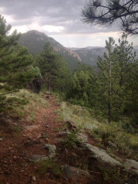

This is a great ride down to the St. Vrain River. Once you arrive at the river, the trail tracks upriver for about 2 miles before heading back up the next canyon to the west. Coulson gulch trail is a fast, flowing single track (some double track too). There are some steep sections that may require a few hike-a-bike sessions if you return up Coulson Gulch as an out-n-back ride. However, if you do the loop and continue on the trail up the next canyon - you will encounter one of the steepest hike-a-bike sessions around. The trail literally goes straight up a steep grade without any switchbacks to ease the grade. It reminds me of a mule trail rather than a mountain bike trail. But still a fantastic climb and ride as a loop. To get the most riding out of your experience - i would recommend riding the loop counter-clockwise. Super fun!
| ThankThere are a lot of reasons to ride this trail. No, it is not a pure singletrack trail. There is doubletrack and 4x4 trail but there is also some very sweet, flowy singletrack to enjoy. The scenery is epic (as my kids would say) and I made multiple stops along the trail to enjoy it.
| ThankThere are some sandy sections and steep rocky hills that might require you to dismount but overall, this was a great ride.
You start off descending (which means you'll end up with a big climb to finish, ugh!) and at the bottom you ride along the North St. Vrain Creek for awhile before the trail takes you up a valley for several miles. You can turn around at any point and head back. There wasn't much traffic on the trail (a few hikers and one other mountain biker who was also fly fishing and provided some friendly directions to me).
It was a fun descent to the doubletrack. It is possible to turn it into loop. Just take a right once you hit the the double track. Then you follow the river upstream until you hit the lake (more of a puddle) where you keep going up. The climb to that point has loose rock but manageable. After that it is a climb from hell. I had to push my bike up, cause there was no way I could make it up. It was not fun, kept sliding down and the climb was pretty long, at least it felt like a lifetime. Once on top, you hit a fire road (4x4 road) keep taking a right and you'll end up in the parking lot. I would recommend doing it CCW and starting the climb with the fire road first and maybe it would be lot more enjoyable, but be prepared for hell of a decline!
| Thank