×

|
Rate it:
Tags:
Level: Intermediate
Length: 10 mi (16.1 km)
Surface: Singletrack
Configuration: Network
Elevation: -
Total: 34 riders
Mountain Biking Moat Mountain
#16 of 114 mountain bike trails in New Hampshire
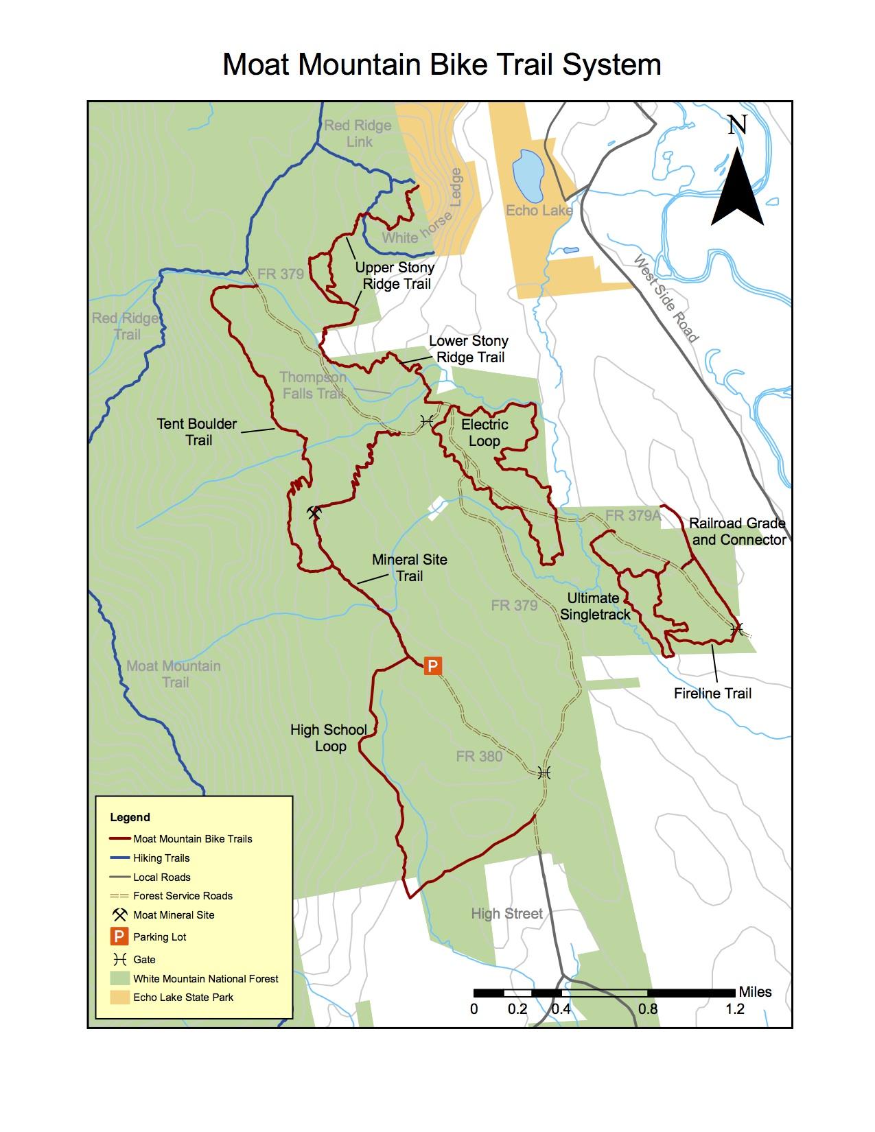
Network of trails including High School trail, Mineral Site Trail, Tent Boulder Trail, Fireline Trail, Ultimate Singletrack, Electric Loop, and Upper and Lower Stony Ridge.
First added by searsandrewj on Oct 4, 2014. Last updated May 1, 2020. → add an update
Before you go
- Drinking water: unknown
- Drinking water: unknown
- Lift service: unknown
- Lift service: unknown
- Night riding: unknown
- Night riding: unknown
- Pump track: unknown
- Pump track: unknown
- Restrooms: unknown
- Restrooms: unknown
- Fat bike grooming: unknown
- Fat bike grooming: unknown
- E-bikes allowed: unknown
- E-bikes allowed: unknown
- Fee required: unknown
- Fee required: unknown
This trail information is user-generated. Help improve this information by suggesting a correction.
From Conway, take Passaconaway Rd. to right turn on High St. Turn right on FS 380 to parking lot.

Great trails. Took a little hunting to find a place to park. Well mark. Going back in the fall
| ThankThis area is awesome. I stayed in a Cedar Creek condo for a long weekend and I could access the trails literally right from the backyard. The land is all White Mtn National Forest owned and is 100% legal. There's even some sick NEMBA singletrack trails. There's also a lot of fireroads perfect for a cyclocross bike. High School DH is really fun. I suggest buying a very good trail map from the WMNF Saco Ranger Station. It's a bit pricey at $7 but it has almost all the trails in Conway. One trail system that isn't shown on the map that I did is a snowmobile area, with some wide trails and also some great singletrack. It can be accessed from 500 m south of where the High School loop meets High St., and also from where the RR tracks cross West Side Rd. The Moat Mtn area can link up with the Echo Lake area trails. Another good trail map resource is Open Street Map.
| Thank