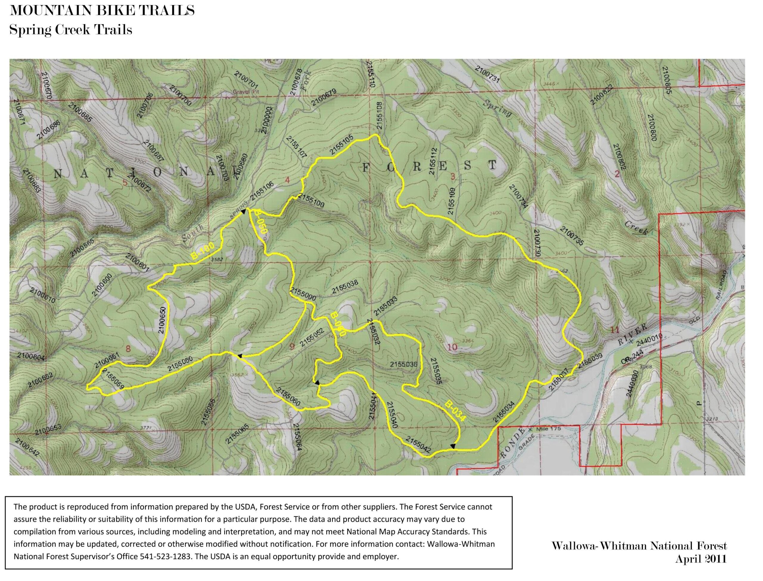
Map of mountain bike trails in Spring Creek, Wallowa-Whitman National Forest. The map features topographical details, marked trails outlined in yellow, and accompanying text about the map
×
User
Today
 
  |   Rate it:

Tags:
Level: Beginner
Length: 6 mi (9.7 km)
Surface: Singletrack
Configuration: Network
Elevation: -
Total: 3 riders
 

Mountain Biking Spring Creek

  Add a review
#209 of 307 mountain bike trails in Oregon
#16,842 in the world

The Spring Creek Bike Trail Loop A (#B-100) is one of four bike trails in the Springs Creek area. The trail is 7.5 miles long and makes an outer loop through the rolling ponderosa pine forested hills. The trails in the area are on open and closed roads. The trail begins at Forest Road 2155 and 034 junction and loops around using other Forest roads.

The Spring Creek Bike Trail B (#B-050) is one of four bike trails in the Springs Creek area. The trail is 1.4 miles long and serves as a cut-off trail for the outer Spring Creek Bike Trail Loop A (#B-100). The trails in the area are on open and closed roads. The trail heads south from the Forest Road 2155 and 034 junction at the B-100 trail.

The Spring Creek Bike Trail C (#B-034) is one of four bike trails in the Springs Creek area. The trail is 1.7 miles long and serves as a southern cut-off trail for the outer Spring Creek Bike Trail Loop A (#B-100). The trails in the area are on open and closed roads. The trail heads south off the Spring Creek Bike Trail B #B-050 and connects with the #B-100 trail.

The Spring Creek Bike Trail D (#B-060) is one of four bike trails in the Springs Creek area. The trail is 0.8 miles long and serves as a southern cut-off trail off the Spring Creek Bike Trail B #B-050 and connects with the #B-100 trail. The trails in the area are on open and closed roads. va. fs.usda.gov

First added by Jeff Barber on Oct 9, 2014. Last updated Apr 28, 2020. → add an update
Before you go
  • Drinking water: unknown
  • Drinking water: unknown
  • Lift service: unknown
  • Lift service: unknown
  • Night riding: unknown
  • Night riding: unknown
  • Pump track: unknown
  • Pump track: unknown
  • Restrooms: unknown
  • Restrooms: unknown
  • Fat bike grooming: unknown
  • Fat bike grooming: unknown
  • E-bikes allowed: unknown
  • E-bikes allowed: unknown
  • Fee required: unknown
  • Fee required: unknown
This trail information is user-generated. Help improve this information by suggesting a correction.
Getting there
From La Grande, Oregon travel north on Interstate 84 about 12 miles to exit 248 at Spring Creek Road/Kamela; On the Spring Creek Road (Forest Road 21) travel 3.5 miles to Forest Road 2155; Turn left on Forest Road 2155 for about 1 mile to the road junction of Forest Road 2155 and 034. The bike trail begins at this junction and goes south on the 2155 road.
Vehicles can park along side the road or off in a open area.


Spring Creek Trail map

Add to or improve this map // Share this map on your website

Local Info

Club Sponsor

-

Local Bike Shop

-

Trail checkins

Upcoming Events

None.
Add one

Trail conditions

(Jan 25, 2025)
login to update

Camping & Lodging

Coming soon!

Spring Creek videos

Add a video
We don't have any videos of this trail yet. Add one here.

Mountain Bike Trails Near La Grande, Oregon

| 12 mi
****
Intermediate | 10 mi

Add a review

Rating
 
Difficulty
 
Review

Reviews

  • Jeff Barber

    Trails are rated easy/beginner.

    Reply | Thank

Rider questions