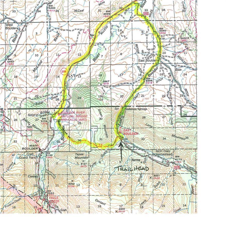
A topographic map showing the Boulder River area, including trails, natural features, and landmarks such as East Boulder and the Boulder River Natural Bridge. The highlighted route in yellow indicates a specific trail path, with markings for various points of interest and elevation contours. Teepee Mt. Saddle / Natural Bridge mountain bike trail.
×
User
Today
 
  |   Rate it:

Tags:
Level: Advanced
Length: 6 mi (9.7 km)
Surface: Singletrack
Configuration: Out & Back
Elevation: -
Total: 4 riders
 

Mountain Biking Teepee Mt. Saddle / Natural Bridge

***   Add a review
#99 of 265 mountain bike trails in Montana
#7,876 in the world

This trail can be done as an out and back, shuttle point to point, or a loop with trail and road. Pick up the trail head on the west side of the road across from the entrance of the campground. Trial starts off with a gradual climb in open meadows and turns to moderate switchbacks in the trees for approx. 2 miles. Terrain here is smooth to slightly rocky. Near the saddle the trail turns to double track and emerges from the trees. Climb now is fairly steep (hike and bike for me) and straight up. From here, enjoy the views from the saddle between Teepee Mt. and Green Mt. Cross the meadow and pick up the decent - look for the fence and trail marker. The singletrack switchbacks on this side have more rocks and roots, so the downhill is a little rougher. Watch for deadfall and be aware of rock runoff diversions. Decend for a couple miles, emerge into a large meadow, and follow trail markers to another short decent followed by a short climb out. Trail nows leads to the Natural Bridge Park area. From here double back, or ride out and around using Hwy. 298 onto Hwy 205. If making a point to point drop a second vehicle here at the Natural Bridge parking area.

First added by eganwh on Jul 14, 2009. Last updated May 6, 2020. → add an update
Before you go
  • Drinking water: unknown
  • Lift service: unknown
  • Night riding: unknown
  • Pump track: unknown
  • Restrooms: unknown
  • Fat bike grooming: unknown
  • E-bikes allowed: unknown
  • Fee required: unknown
This trail information is user-generated. Help improve this information by suggesting a correction.
Getting there
Take Hwy 298 south out of Big Timber for approx. 18-miles. Turn left onto 205 and continue on for 7.5 miles to East Boulder FS Campground. Park here.


Teepee Mt. Saddle / Natural Bridge Trail map

Add to or improve this map // Share this map on your website

Local Info

Club Sponsor

-

Local Bike Shop

Trail checkins

Upcoming Events

None.
Add one

Trail conditions

(Jan 3, 2025)
login to update

Camping & Lodging

Coming soon!

Teepee Mt. Saddle / Natural Bridge videos

Add a video
We don't have any videos of this trail yet. Add one here.

Add a review

Rating
 
Difficulty
 
Review

Reviews

  • eganwh
    ***

    Moderate climb with strenuous sections on east side. Technical downhill with roots and rocks on west side.* Review edited 7/14/2009

    Reply | Thank

Rider questions