After parking return to Bear Meadows RD and follow the road up the mountain until Corner RD on the left. At Corner RD turn left, this road will end at a gate where the single track begins. Follow this trail (Camp Tr) up the mountain until intersecting with a beer tap (sorry not usually stocked). At the beer tap turn right, this is now Tussey Mountain Tr. Follow the trail until intersecting back with Bear Meadow RD. Cross Bear Meadow, and slightly down the road to the left will be a gate, beyond the gate is the trail head for Longberger Path (right turn). Follow this trail, it will intersect with the Kettle Trail and then after a long downhill section come to a fork. At the fork turn right, you'll follow a short trail back to Bear Meadow RD and the parking lot area.


 3
3
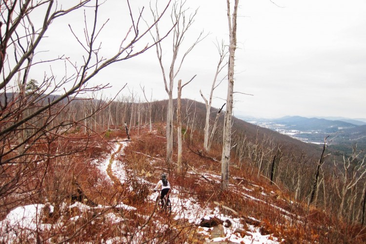
As with most of Rothrock, it's rocky but loads of fun; challenging with awesome vistas to enjoy when you stop. Tough to look when you're hopping rocks!
| ThankSkinny hiking style trail. There were a lot of rocks, and it was a bumpy ride. I ride a hardtail, and I would definitely recommend a full suspension. Fun overall.
| ThankGreat ride if you love Rocks and technical riding. This is definitely an advanced ride I had to walk through a few sections as the rocks are tombstones and boulders in some sections. I did have a ton of pedal strikes along the way.
I bought a purple Lizard map and learned as I rode. You can get one at Rothrock outfitter in town. This map comes in handy and it is waterproof. Take it with you as it can be confusing up on the mountain.
I rode the opposite direction as the below route Which made for some steep rocky climbs. I feel I gained some new skills on this ride.I do wish I had brought my full suspension bike instead of the hardtail.
I suffered a pinch flat . However the views from the ridge where worth the climb.
I met a group of local riders a judge ,lawyer and a engineer, they gave me much needed directions to get back over the private land.
I was welcomed back at the parking lot by them with some ice cold beverages and great conversations.
| ThankNice meeting you guys.
Maybe one of the best views of any trail in the area, especially in the burn zone. Moderate easy climb up the end of the ridge, and then a rocky, technical ride out the spine of the ridge.
| ThankToo much small narrow rock for my liking. I much prefer Moraines larger Rock gardens but that just me
| ThankI used to live in State College and hiked these trails all the time. But I'd never ridden them until 7/14/12.
Wicked. I started at the Mountain Rd parking area and headed up Shingletown Trail. A lot of big rocks, but with practice this could be a nice challenge. Crossed Laurel Run rd and continued practically straight up the mountain. This part is for super-experts. I walked up most of the way.
When I got to Little Flat Rd, I hung a left and picked up the Old Laurel Run trail a few feet down on the left. This is a very challenging down hill with almost as many rocks as the climb. Don't attempt this unless you are sure of your abilities! I had to give my hands and feet a break halfway down, but luckily didn't crash.
At the bottom of that I picked up Longberger trail. By the way, if you can cross all 3 of those bridges without dying, you should be getting paid for this.
I followed Longberger until it intersected with Kettle trail, turned right on Bear Meadows and found Tuxedo Trail, after some confusion. This was another wicked climb up!
Then it straightens out and eventually becomes Tussey Mt Trail. This part was awesome. Some sweet rock obstacles to go over, that are challenging but not too crazy. You could really have a fast and fun sprint here, but you might get distracted by the mountain vistas to the right and will want to stop to take pictures.
By this time I knew I should start heading back, so I decided to take the Filmore trail as a shortcut back. I must've already passed it, and opted to keep going rather than double back. I knew I wasn't far from Tussey amusement area, so I took a chance and decided to seek water there. Right as I reached the beer tap, I ran out of water--the beer tap, of course, bone dry. But at least I knew exactly where I was. (I had downloaded trail maps courtesy of NMBA's website.) I made my way down Galbreath gap tr/Corner Rd/Bear Meadows Rd, to the ski resort. They were not only open, but they had cooler full free ice water, a courtesy bike maintenance station, and a surprisingly awesome hot dog trailer. After a few stretches, gulping and refilling my hydration pack, and one giant Mountain Dog, I was on my way. Across from the Galbreath Gap Parking lot, I took the zig zaggy trail which lead to Laurel Run Rd. I decided to take the road :/ as a shortcut to get back to Shingletown Tr. I was so beat by this time. Once I got to Shingletown Tr it was mostly down hill, but crazy rocks! I made it to my car, surprisingly unscathed, save for a few scratches. This is a great challenging, beautiful trail system--I recommend this for people who want to up their experience!! Definitely not for beginners.
| Thank