


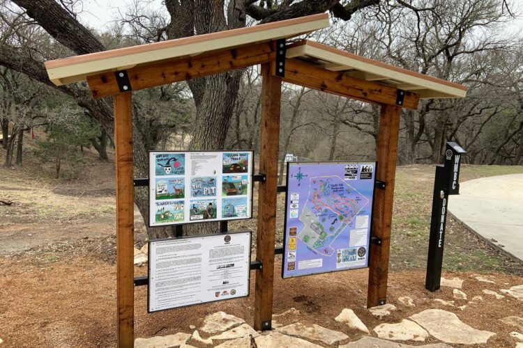
The WMBC is happy to announce that the new trail in Mineral Wells is open! The Western Heritage Park Trail (WHiP Trail) is located at 3051 North Oak Avenue (approximately 1.6 miles north of downtown). Once you enter the park please park in and around the grass to your right. If the parking area is full you may park in the overflow parking on Shattles Road (which is directly across the street from the park entrance). The trailhead kiosk is adjacent to the west parking area. Please read the Rules of the Trail and Trail Map. It is a good idea to take a photo of the trail map until you become familiar with the routes. The approximately 4.35-mile loop consists of 3 trails (Blue to Red to Green). There is a two-way roadway/trail (Orange) that bisects the park. Below is a description of each of the trails. We will get a high-resolution PDF of the map available for downloading soon. ORANGE TRAIL: The Orange Trail is essentially a beginner level, two-way road used to access the Red and Green Trails. This roadway/trail is marked with two-way markers along the route. There are also trail markers noting where the entrances to the Red and Green Trails are located. This roadway/trail has many different surfaces (asphalt, gravel, double-track, and trail). Please stay to the right when traversing the Orange Trail. This trail is also used by Mineral Wells Fire/EMS when required for emergency access. Points of interest along the Orange Trail are the WPA built rock bridge and other features including rock staircases and an abandon rock structure. GREEN TRAIL: The Green Trail is accessed via the Orange Trail. The entrance is on the other side of the WPA Rock Bridge. The Green Trail is considered a novice/beginner level trail. There are no rock gardens or technical elements other than a few dips, tight turns, and rollers. Points of interest along the Green Trail are views of Pollard Creek, riding under very large cedar elm and pecans and a cool land bridge. Families can access the 6 picnic tables throughout the Green Trail to serve as their home base for rides. The WMBC would very much like for mountain bikers of all skill levels to ride the Green Trail to encourage kids and beginners. BLUE TRAIL: The Blue Trail is the entrance to the singletrack WHiP Trail Loop. This trail is marked with one-way markers along the route. The Blue Trail is considered an intermediate level trail. However, there are several challenging rock gardens riders will encounter along the way. Be patient when riding these rock gardens. They all have ride-able lines once you identify them. Points of interest along the Blue Trail are the views to the west and the ride along the top of a bluff looking east into the park. The end of the Blue Trail is near the trailhead. You can easily bypass the Red Trail and either ride another lap of the Blue Trail or access other parts of the park via the Orange Trail. RED TRAIL: The Red Trail begins immediately at the end of the Blue Trail. This trail is marked with one-way trail markers along the route. The Red Trail(s) are considered expert level trails. Bikers should adhere to a “ride slow to go fast” philosophy when riding these trails. There are numerous rock gardens, climbs and descents throughout. Think being a diesel rather than a sportscar when riding these trails. If you override the Red Trail(s) you are in for a bad day on the bike. We have dubbed a rock garden near EMT H the name, NC-17. Points of interest along the Red Trails are ROCKS, land bridges and some amazing trees. EMT POINTS: Emergency Medical Technician points are along all the trails. They are noted in alphabetical order, letter A thru P. Should you require medical assistance along the trail call 911. Give the dispatch operator your location (EMT A, for instance). Mineral Wells Fire/EMS has a KMZ file of the WHiP Trail and all EMT locations. Follow their instructions. This EMT system is in use at Quanah Hill and the Parks of Aledo Trail.


Made the trip out from DFW. It was a hike but worth it. This trail is more like a classic cross-country trail epic, but considerably shorter. There are currently 3 loops: an easy green loop which is very sandy and mostly flat with some tight corners. The intermediate blue loop, which is sandy and rocky somewhat technical but someone with good line choice could make the argument that it's flow tech. And then the red trail which is a rock crawl puzzle in which you won't be going fast but is so fun to figure out and requires a lot of balance. There's good wildlife and scenary on My only concern for
| Thank