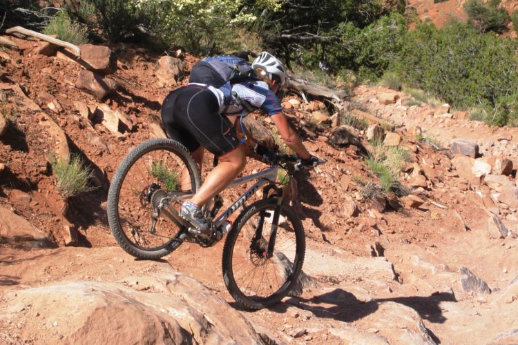
This trail was named after Kokopelli,the ancient god of fertility. The hump-back flute player, is a symbol seen all over the southwest. Kokopelli's Trail starts in Loma and goes all the way to Moab about 140 miles. A combination of dirt, OHV, and 4x4 roads with some singletrack. The trail is marked every 1/4 mile and at intersections, look for the Kokopelli symbol. The first 12 miles is mostly singletrack with some nice rock drops that are like stairs, some exposure, and some tecnical sections that you will probably have to carry your bike across. This is a spectacular canyon with great views. Sometimes you are only riding a few feet from the edge of huge dropoffs!! Check out the trailhead map or pick up a copy at the Welcome Colorado Inf. center in Fruita. From the parking lot head west on the frontage road turn left and cross the ridge. Just past More Fun Trail there is a nice singletrack that parallels the road . At about .5 the trail takes off to the right. This is a short climb that turns into a nice slickrock section. At 2 miles you come to Horsethief Bench Loop a 3.6 loop that's hard to pass up! Continue on you will come to a gate then Mary's Kiosk just past this you will get a taste of the tecnical sections to come. At 5.5 miles Steve's Loop takes off to the left although not the designated route this 3 mile loop is the way I always go. It's my favorite loop, with the most exposure. It rejoins the Kokopelli Trail and Mary's Loop. Follow the Kokopelli Trail signs as the trail follws part of the Lyon's Loop that takes off to the west. This is where the trail gets more difficult and steep the trail turns into singletrack when you come out the road turn right and start climbing back up the ridge after about 3/4 mile the Kokopelli Trail takes off to the left an follows part of Troy Built Loop. Some nice downhill singltrack here. you will come to a sandstone creek bottom the trail is kind of obscure here so look for the rock carins. Juat past this section you can see the Kokopelli trail as it makes it's way down to Salt Creek Once you cross the Salt Creek Bridge prepare yourself for a hike-a-bike section up to the top of the ridge.Once on top of the ridge the trail follows a road in the directin of I-70.Just before I-70 the Kokopelli trail takes off to the west and follows Rabbit Valley Road one more hill and it's downhill for a well deserved rest. Follow the Kokopelli Trail through Rabbit Valley.A couple miles past Rabbit Valley You come to a rock formation known as Castle Rock the Utah State Line is a short distance further. There are many ways to do this ride: a lolopop from Rabbit Valley, a point to point shuttle or ride it in two parts You will just have to figure out your favorite route.


 1
1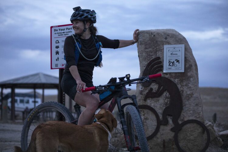


I rode the "east section" of Kokopelli two days ago and came over to the "west section" today. Kokopelli is the most complete network I've found in GJ/Fruita. Trails are very accurately rated and all routes and intersections are very clearly marked. The east side trails had some more technical riding. I went up Moore Fun (the most technical climb in the valley), took Mary's to Steve's (flat rim rock trail with amazing views) then back to Mary's and over the Horsethief (the pride of the network featuring lots of fun, with some flow, some rocks, some step ups and offs) then returned to TH via Mary's.
West side I rode up Hawkeye to Troy Built, to Lion's all the way down to Mary's, back to Mack Ridge and climbed to Hawkeye and had a nice flight back to the parking lot. Lotsa cool stuff on this side with a variety of ups and downs. The route I took sent me from the parking lot, to the top, bombed down to the bottom, back to the top, and once again back down and up again with a really fun final decent.
Definitely the best recommendation in the valley to experience the best variety of riding. Great stops include Over the Edge Sports bike shop in Fruita and Bestslope Coffee in Fruita as well
| ThankThis is a great newtwork with a wide variety of riding. Trail legends are very accurate to skill levels. Got my info from Pete at Iver the Edge Soorts and he was spot on. Moore Fun was a great technical climb from the trail head, tied in to Steve's for a nice run rock ride, then took Mary's down to Horsethief, which is a must do directional section with some flow, some speed, some tech, then finished up with Rustler's, which is another directional loop. Nicely laid out trails and in really good shape overall.
| ThankUpdate on temporary closure, from the USFS:
| Thank"the Loop Road will be closed between Miners Basin and the Castle Valley Overlook until May 27th (Memorial Day Weekend). "
Update from the Forest Service about a closure:
"The La Sal Loop Road will be undergoing construction this summer and portions of it will be closed, including a portion of it that is used by the Kokopelli Trail."
| ThankI've ridden Mary's Loop & Horsethief. Fantastic views but the trail system needs better markings at the roads. Once you're on the trails they are marked but you have to figure out where they start. Full review and video here.
| Thankhttp://getsomeadventures.com/can-you-ride-the-kokopelli-trails-in-colorado/
The Kokopelli's Loop Area is still my favorite section of the trail. The only bummer is all the people especially if you get caught in the Bikerpelli crowd!Rode koko/ Horsethief/ Steve's and back koko. Noticed new Wrangler Loop but didn't ride it.
| ThankThis one has it all.
| ThankSome of the best singletrack and dynamic trail systems in the midwest are at the beggining of this trail - In fact most of the technical singletrack for this whole trail is in the first 20-30 miles. After that, a great deal of this ride is done on 4x4 roads, however - don't think for a minute that this makes it an easy ride...there are spots (Rose Garden) where you WILL walk or carry your bike.
There are Kokopelli Trail markers with clearly marked arrows every mile or so along this trail. Keep in mind that without a map or previous knowledge of the area it is easy to get turned around in the first 20-30 miles of this ride.
Most guided/supported tours (that you can join in and pay for) ride this trail in 6 days...a few friends and I did it in 4 - although it could have been 3 days if it hadn't been for the bad weather (mud/clay) and broken derailleurs (2) on day 1.
Best advice: Take TOO MUCH water...you will not be sorry for taking too much water because there is NO water along the trail. None.
Rode the Kokopelli from Loma to Moab, 140 miles in 4 days, epic for sure, but I was disappointed there wasn't more singletrack...overall this was an awesome ride and I would recommend it to anyone looking for a few days on the trail looking at some truly beautiful vistas.
| ThankThis trail has a lot of great singletrack and technical spots, but it also has amazing veiws.
| ThankOnce you get off the sandy 4x4 road, the trail is pretty awesome. Watch out for thorns in the parking lots. I picked up 2 flats on my front wheel and 1 on the rear on the same ride. Bring plenty of water.
| ThankWOW....what an amazing trail the scenery is unbelieveable. We rode all day..well until it started hailing on us..definetly an awesome alternative to the Fruita area trails..we'll be back soon!
| Thank