
In 2007, the Angora Fire ripped through 3,100 acres of land near South Lake Tahoe, destroying hundreds of homes and commercial buildings. The disaster occurred before the mega fires that make headlines today, but it still devastated the community and impacted trails used by mountain bikers and other trail users.
There are dozens of similar examples throughout the United States and around the world. In regions like Bentonville, AR, fires are less common, but the community is still vulnerable to extreme weather, demonstrated by the series of tornadoes that struck the Ozark town in May.
As climate change causes more instances of extreme weather, these unfortunate events are increasingly on the minds of homeowners, businesses, and mountain bikers alike. The communities in Tahoe, Windsor, Durango, Darrington, Bentonville, and beyond have been resilient, painting a picture of how trail towns can recover and re-open mountain bike trails.
Tahoe’s recovery from the Angora Fire and Caldor Fire
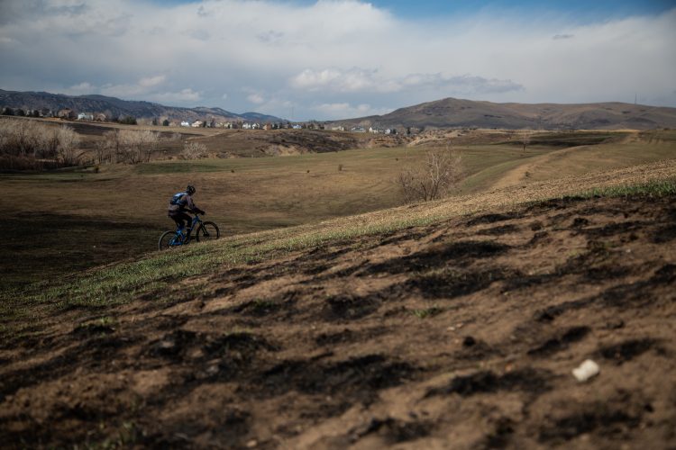
That fire in summer 2007 destroyed nearly 100 percent of the forest surrounding the Gunmount Trail, a multi-use trail that passes near neighborhoods, said Drew Bray, executive director of Tahoe Area Mountain Biking Association (TAMBA).
After the flames subsided, the Forest Service removed burnt trees and replanted extensive vegetation to prevent erosion. In subsequent years, TAMBA constructed the Mule Deer trail, which is popular among mountain bikers and heads onto a ridgeline.
“[The] trails are fun,” said Brae. “They ride well, it’s a different environment. There’s no forest of any sort. The early pioneering species that come through there is pretty heavy — whitethorn. It’s a natural species that comes in after fire. There are some aspen stands and some wet areas.”
While the Angora zone has seen re-growth and additional trail construction, the Caldor Fire swept through in 2021, burning 221,835 acres and more than 1,000 buildings. In addition, many popular trails were impacted, including Warr Trail, Saxon Creek (Mr. Toad’s Wild Ride), Armstrong Connector, and Corral Trail, as well as routes such as the Tahoe Rim Trail and Pacific Crest Trail.
Again, the first step for TAMBA and the Forest Service was to remove trees and conduct erosion prevention work. When forests burn, burnt trees that are still standing create a fall hazard, and revegetation helps stabilize scorched hillsides.
The removal of ash from the trail surface was also needed, Brae said, as was placing trees and obstacles alongside trails to encourage people to stay on the trail, since the forest was now much more open and vulnerable to off-trail riding. Brae also noted that trail armoring played a factor in which trails were more resilient.
“Trails that were armored with organic material, such as wood or anything like that, everything was destroyed in the fire,” he said. “For trails we had done some recent work on — Armstrong Connector as an example, and on Toad’s — where we had used native materials such as rock to armor trails, those trails held up really well.”
Fires have highlighted the importance of trail organizations having strong relationships with land managers and fire agencies, as trails can be used as fire breaks, for fire mitigation, and as access points for firefighters.
This point was echoed by Mike Westra from Evergreen Mountain Bike Alliance.
“If there is a disaster on the trails, the local community should come together because that’s when your land manager is going to listen to you,” Westra said. “Come together, help fix it back up, offer to build new trails.”
In recent years, Evergreen led efforts to restore upwards of 40 miles of trails after 2021’s Cedar Creek and Cub Creek 2 fires outside of Windsor, Washington. Those efforts included fundraising and securing a Burned Area Emergency Response (BAER) grant from the Forest Service, which is a program that seeks to restore trails, communities, and wildlife in burned areas on federal land.
Another such example of a BAER grant followed the 416 Fire outside of Durango, CO, which burned trails and large swaths of the San Juan National Forest, including the popular Hermosa Creek Trail. This Forest Service BAER document showcases just how many impacts the forest suffered in summer 2018.
From disaster to opportunity: The North Mountain Trails in Darrington, WA
A unique example of mountain bike trails being used to spur community and economic growth is ongoing after the Oso landslide near Darrington, Washington, just northeast of Seattle, in 2014. The slide killed 43 people and destroyed 49 structures in a river valley.
There were no established mountain bike trails in the area at the time, though mountain bikers often passed through on their way down the highway to other trail systems. As the community looked to rebuild, the potential to add mountain bike trails became apparent.
A fire lookout at the top of North Mountain was going to be restored, said Westra, Evergreen’s trails director at the time. Mountain bikers started chiming in, and Evergreen got involved to survey the area, put together a plan, and secure funding. Evergreen broke ground on new trails on North Mountain in 2016 after environmental studies and permitting from two different counties.
Today, the mountain features 14 miles of trail, ranging from upper-intermediate to double black diamond trails that can be shuttled and used by e-bikes. Evergreen is currently looking to secure funding for seven additional miles of trail, which would create a top-bottom run with 3,200ft of vertical drop.
Trail builders from the local area worked on the trails, and since the trails opened, businesses have popped up, such as a coffee shop, a brewery, and a popular campground right at the base of the trails.
“The trails were a catalyst for that to happen,” Westra said. “Snohomish County had this wide open space that just was never used. It’s just something they had to mow the lawn regularly, and that was all it was used for was to put a lawn mower. Now they built this beautiful campground.”
Mountain bike events are also building community and stoking economic activity in Darrington. An all-women’s dig and ride camp out attracted about 60 participants earlier this spring.


Tornado recovery in Bentonville, AR
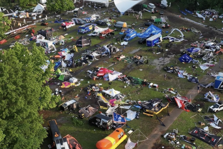
Several tornadoes hit Bentonville over Memorial Day weekend, and nearly every trail in Bentonville sustained some type of damage, said Meghan Feyerabend of the Trailblazers. Trails in nearby Rogers and Bella Vista were also impacted.
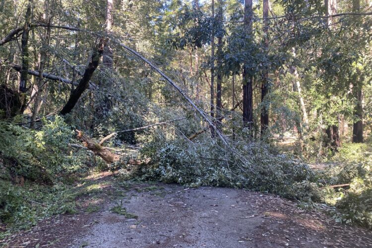
The Slaughter Pen and Coler trail systems were hit the hardest, with fallen trees causing most of the damage. Not only does this create painstaking labor for trail crews, but it will also change the character of the riding in Bentonville going forward.
“It’s not just like a tree is down, it’s thousands of trees are down,” said Feyerabend. “They’re also twisted up in each other. There’s root balls, there’s hangers. It’s a really complicated process.”
In addition to the trees, trail features like bridges were damaged, and hillside trails have been washed out because the trees and vegetation previously supporting the hillside have been destroyed.
So far, Trailblazer crews and volunteers have worked to accomplish the easiest tasks first, such as reopening Oz Castle and Hand Cut Hollow, which were not hit as hard by the storms.
Full recovery will be a long-term process, however, with the Trailblazers estimating that they have a full year’s worth of work ahead of them.
The Trailblazers organization has also been pacing themselves to avoid burnout and is ensuring that trail users are aware of the current status of trail closures.
Historically, mountain biking has been less popular in tornado-prone regions of the country like Arkansas, Oklahoma, or Kansas, so there are fewer examples to look to for how to rebuild mountain bike trail systems hit by these storms.
“It’s definitely unprecedented, and we’re trying to figure out how to deal with it on the fly,” Feyerabend said. “There really isn’t any protocol, I would say, for this kind of damage, because we have thousands of trees. Like, it’s immeasurable the amount of trees that we’ve lost and have had to deal with.”
As of the time of this writing, 16 trails in Bentonville are fully open, with 35 trails being rideable but still having damaged sections. 95 trails still remain closed. The majority of trails in Bella Vista are open, since that area did not get hit as hard.
Feyerabend said that there has been huge community support, with businesses paying their employees to volunteer and group rides volunteering during their regular ride times, among other initiatives.
“It really speaks to the community that we have in Bentonville, and how passionate people are about mountain biking, but also how well people are working together.”
The work continues
There are countless examples of similar disaster recovery scenarios. Two bike parks are being developed in West Virginia after the town of White Sulphur Springs suffered flooding in 2016. Trails at Blue Derby in Tasmania were repaired in the nick of time after a landslide caused damage ahead of last year’s Enduro World Cup race.
There will inevitably be additional tragic events, but as these stories show, hard work from trail groups, communities, and land managers can revitalize impacted areas and keep the wheels rolling.





0 Comments