


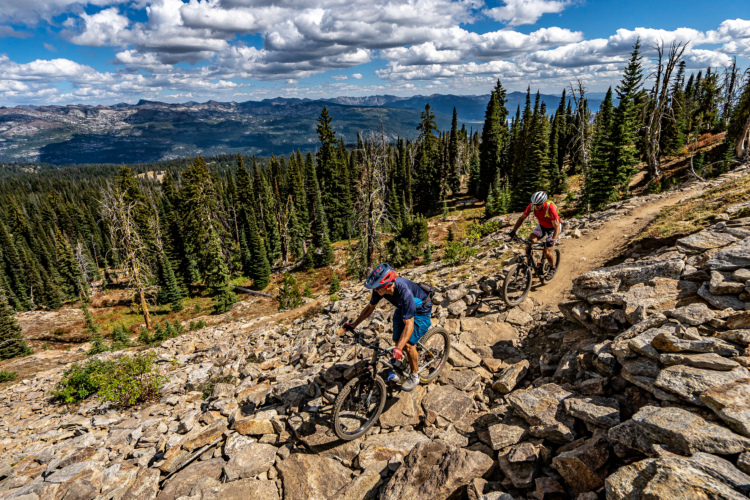
The small town of Salmon, ID, is the epicenter of mountain biking in Lemhi County. Lemhi County only has 8,200 residents, yet it boasts over 1,200 miles of rugged backcountry singletrack. In a landscape so vast and overwhelming, where do you even begin to ride?
I spent over a week mountain biking in Salmon on a recent trip, and as I drove over the Continental Divide and dropped into Montana, I realized that I had barely scratched the surface of what the area has to offer. As I perused online maps and tried to parse out the different riding zones, I quickly became overwhelmed with the options. So, I consulted Bill MacFarlene, Secretary of the Salmon Idaho Mountain Bike Association (SIMBA), and long-time local Dave Lingle, member of the North Fork Trails Alliance (NFTA), to help me get the lay of the land.
The complex web of singletrack near Salmon can be subdivided into distinct networks within the larger web of interconnected trails. After talking with both MacFarlene and Lingle, I was able to hone in on five of the best networks within this expansive system.
Like most mountain bike destinations worth their salt (or at least the ones I enjoy the most), Salmon offers a wide array of trails at different elevations, giving each area a different ecosystem and flavor. As such, different trails are ideal at different times of the year. In this roundup, I’ll begin at the low elevations and then move higher up the mountains.

Discovery Hill
The Discovery Hill trails are Salmon’s in-town trail system. Most of the trails at Discovery Hill began life as motorcycle trails or cow trails and have since been adopted by mountain bikers. This low, arid trail network opens early in the season — generally in March or April — and stays open into the early winter, providing Salmon with a lengthy riding season such a northern latitude. During the shoulder season, riders flock from all over Idaho, Montana, and Wyoming to ride dry singletrack in Salmon.
Discovery Hill has been a focal point of mountain bike advocacy in the area. The adoption of these trails into a designated trail system and the installation of signage and ongoing maintenance was a massive win by local mountain bike advocates.
During the winter, the Discovery Hill trails often get traffic packed for fat biking, providing year-round pedaling. As all fat bikers know, snow riding conditions are very weather-dependent, and the quality of the fat biking can vary dramatically from year to year.
Standout trails at Discovery Hill include Slump Ridge and Enduro.

Wagonhammer
Wagonhammer is the next step up in elevation. This popular trail system hugs steep-sided mountain slopes covered in sagebrush and forest. In May, the wildflowers on these mountainsides are unbeatable! Many local riders rave about Wagonhammer as their favorite trail system in Salmon.
But once summer hits, this area gets very snakey, with countless rattlers hiding in the tall grass. Wagonhammer is also grazed by cattle beginning sometime in June, which is necessary to keep the trails from getting overgrown but also makes it less desirable to ride at that time. Sharing trails with cattle is common on many of the networks in the region, and the locals rotate their riding based on cattle grazing as well as temperature.
Stein Ridge trail is one of the standouts at Wagonhammer, but it will take some work to reach it (like most trails in Salmon). For an epic view and a bit of a beat down, consider climbing all the way to the Stein Mountain Overlook.

Twelvemile
Twelvemile is one of the closest trail systems to the town of Salmon, but most of the trails are high in the mountains, requiring a drive (or ride) nine miles up a rough forest road with about 2,500 feet of climbing. While one epic ride — Lime Creek — drops out of the Twelvemile area, it’s not really loopable with the road climb.
To solve connectivity in this network, SIMBA is working to get approval to build a climbing trail that will allow riders to pedal up to this gem of a trail system. Also included in the proposal are key connections within the trail system to create more loop options, which will make for a more enjoyable riding experience.
Despite being so close to Salmon, the trails high in the mountains in Twelvemile are generally quite shaded and thickly-wooded due to narrow mountain valleys, providing cooler riding opportunities than the dry, dusty trails down low.

Williams Creek
Located just across the highway from Twelvemile is the Williams Creek area. This zone is popular in part because it makes for a relatively easy shuttle. Some trails provide the opportunity for short laps with zero climbing, and it’s also possible to create a much longer point-to-point route. However, you’ll still have to coordinate all logistics on your own — no commercial shuttle operations exist in Salmon.
The upper reaches of this zone run through deep pine forests, with the occasional meadow opening up with brilliant wildflowers. Lower down, the trails drop back into sagebrush terrain, with wide-open slopes providing majestic views of the Beaverhead Mountains across the valley.
Must-ride trails include Powderhouse to Perreau.

Chief Joseph Pass
Chief Joseph Pass is a paved highway pass that crosses the Continental Divide on the Montana/Idaho state line. The pass is a jumping-off point for a dizzying array of trails, some of which drop toward the Idaho side of the Divide and others that drop toward the Montana side. Chief Joseph Pass is one of the highest-elevation riding areas close to Salmon, although sections of the Continental Divide Trail further south near Leadore do get higher.
The mountain bike rides off of Chief Joseph are anchored by the Continental Divide Trail, which provides access to both pedal-driven loops and fantastic descents down Salmon’s steep, natural trails. Two of the most renowned descents to the Idaho side are Sheep Creek and Threemile Ridge, while Warm Springs Ridge to the Montana side is possibly the most famous trail in the region, albeit not technically in the Salmon zone.
Many areas have burned near the Pass in recent years, creating an eerie landscape filled with the still-standing blackened trunks of dead trees. However, life will always persevere — carpets of wildflowers and first growth vegetation are already growing through the ash-covered landscape. Since the fire burned down many areas of dense undergrowth, some of the trails in the area are riding better than ever.

Parting thoughts
Are these all of the trails in Salmon, Idaho? Far from it.
Did I out any secrets in this round-up? Definitely not.
While I’ve provided an overview of each area, this isn’t intended to be a list of recommended routes. Within each network of trails, there’s an astonishing array of route options to choose from. To determine which is best for you and your riding style, you’ll still have to do some homework to “earn” the best rides in Salmon — even with the vast amount of information available online on mapping sites like Singletracks and Trailforks.
And locals like Lingle think that’s okay. Folks like Lingle are hardy riders who have been pedaling bikes longer than I’ve been alive, and they still embrace a rugged, backcountry ethos around everything related to the sport of mountain biking.
As I wrote in my first article, you need to be prepared when you come to Salmon — and that includes route planning and plenty of navigational know-how. In even the most popular areas, you can expect to encounter unmarked trails, deadfall, and singletrack that’s so grassy it might be difficult to spot the next trail junction. You need to be prepared for all of these eventualities… but if you are, Salmon’s epic trails will reward you with the trip of a lifetime.


1 Comments
Aug 13, 2024