


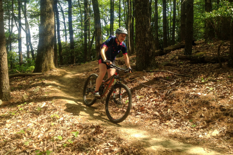
For many years, a popular network of singletrack trails in the Pisgah National Forest close to the fish hatchery was home to a very confusing stretch of singletrack. This short connector, known as “Cat Gap,” formed a critical link between the Butter Gap trail and the lower parking lot at the hatchery.
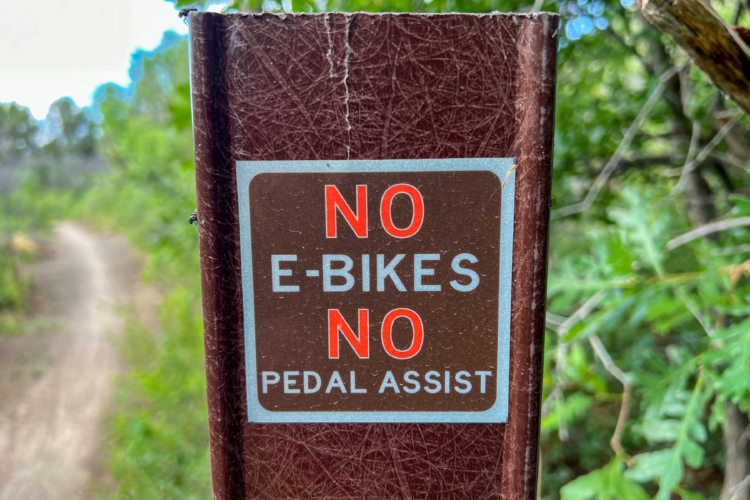
The confusion arose from a strange seasonal closure that banned mountain bikes on the Cat Gap trail from April 15 to October 15 — six months of the year. The closure itself was strange because it wasn’t established to protect wildlife, as is common in many other areas of the nation. Instead, the seasonal bike closure was intended to reduce negative user conflicts between mountain bikers and hikers.
Cat Gap also forms a critical connection for a popular hiking loop from the hatchery that heads up to John Rock, so the US Forest Service decided that shutting the trail to mountain bikes for half of the year would solve the problem. The seasonal closure effectively blocked one of Pisgah National Forest’s best mountain bike loop rides, which climbs Searcy Creek and descends Butter Gap, finishing with that vital connection on Cat Gap.
Thanks to a new reroute of Butter Gap and the Lower Butter Gap trail, this critical section of singletrack is now open to mountain bikers all year round. But not only that, the hard work by Pisgah Area SORBA and the US Forest Service (USFS) is proving beneficial for both user groups. The mountain bikers have gotten a bike-optimized trail through this area of the forest, while the hikers now get to enjoy a hike-only trail where they can walk without having to worry about bike traffic.
Everybody wins!
So, how did this innovative solution come to pass?

Butter Gap was identified as an erosion problem in 2013.
“2013 is when the [Butter Gap] trail was identified [by the Forest Service] as not sustainable and would need to be rehabilitated or rerouted in some way,” said Natalie Narburgh, Executive Director for Pisgah Area SORBA.
“Grogan Creek runs all the way along Butter Gap, and the erosion due to the unsustainability of Butter was so bad that it was just dumping sediment into Grogan Creek, which supplies Davidson River,” said Narburgh. “At the very bottom of Butter Gap trail is the fish hatchery. All of those trout were being affected by the erosion from the trail. So that’s why Butter was such a big deal and needed to be addressed.”
According to Narburgh, many trails in the Pisgah National Forest were eroding so badly that they had to be rerouted, or the USFS would have to close them altogether. While Butter Gap was first identified as a problem in 2013, Pisgah Area SORBA had a whole list of trails that were a higher priority to address before Butter Gap — most notably, the massive reroute of the iconic Black Mountain trail.
“2018 is when the project was actually put on a plan for the Forest Service for it to get taken care of,” said Narburgh. Pisgah Area SORBA was awarded a $100,000 RTP grant for the project that same year, but the project wasn’t completed until 2024.
In the intervening six years, the NEPA process had to be completed for the proposed reroutes and new trail construction connected to this project. Pisgah Area SORBA also completed other big projects during that time, such as the aforementioned Black Mountain Trail. They were also able to complete fundraising for the $250,000 project from Transylvania County Tourism, Fox Factory, Athletic Brewing, and what was essentially a bridge loan from Sierra Nevada Brewing.
After all of this work, the new-and-improved Upper and Lower Butter Gap trails along with the Searcy Creek Connector trail are all ready to ride in a fantastic 15-mile loop!

Beautiful new singletrack in the Pisgah National Forest
In total, 5.5 miles of brand-new singletrack were built in this area, along with an additional 1.5 miles of trail maintenance and improvement work. 0.75 miles of singletrack was also decommissioned. This total includes the new hiking-only trail, known as Picklesimer, as well as the one-mile Searcy Creek Connector. The Searcy Creek Connector project was led by the Pisgah Conservancy, which contracted the Pisgah Pathologist for the trail build.
The new Butter Gap trail is designed to be multi-use and multi-directional, but Rock Solid Trail Contracting — the company that Pisgah Area SORBA contracted for their portion of the trail work, which includes all of Butter Gap — worked to retain a classic Pisgah flavor while creating a fun downhill that mountain bikers will have a blast on.
The newly revamped Butter Gap trail has “got some nice, steep downhill bits,” said Adam Munich, Digital Marketing Coordinator for Rock Solid Trail Contracting. “It’s definitely one of those flow trails that you really have to watch your speed on since it is kind of a backcountry trail — it doesn’t have big bike park berms, so it’s really easy to get really fast on the downhills and then, ‘okay, this is a climbing turn!’ So it is a really unique trail that is fairly steeply graded for this rolling contour style, really well-draining trail.”
If you’ve ridden Butter Gap in the past and written it off, or if you never attempted to connect this loop before, now is the time to check out this instant classic hidden deep in the Pisgah National Forest!


6 Comments
Jul 24, 2024
Jul 24, 2024
Jul 24, 2024
Jul 25, 2024
Jan 24, 2025
First, Butter Gap was never "technical" in the sense of the rest of Pisgah. The sections that were technical, were largely due to the narrow surface combined with exposed roots. These sections were among the most consistent trail in Pisgah and barely changed in the decade or more since I first rode it. They barely, if at all, eroded. The roots acted like a natural erosion barrier and most of the sections were not near the river.
The sections that did have erosion problems were well known and identified, but they were short segments scattered through the trail. Some of them were opened up or made worse by Hurricane Fred several years prior and continued to degrade, no doubting that, but in sum total you are talking about 100ft of trail across the entire trail - at most. Some of this was actually on Cat Gap, a previously seasonal trail that is now hiking only - one folks often conflate with Butter because they connect. The worst offender was in the middle of the trail, it was a spring that would overflow and run down the length of a segment then dump off into the nearby rivers and streams. The sections on Cat were re-routed before the full re-route was done and were no doubt problems, but these re-routes were often only 10-15ft of changes. They also built new bridges over several water sources that previously users would ride or walk through.
Additionally, the USFS has been trying for years to keep riders out of streams and the upper segment of the trail had 4 or 5 stream crossings.
That out of the way - unlike other trails, Butter was not technical due to erosion except for a handful of short segments, unlike trails like Black/Avery/Bennett where their challenge came from eroded segments - Butters trail surface was more resilient and less eroded. In the decade I've ridden it, it rarely changed at all. The reason there is so much uproar over the change is that a non-local contractor was chosen, but also that the new trail is not characteristic of the old one - at all. Some, like myself, don't see where cutting several miles of entirely new trail over what amounts to less than 100ft of problematic trail is somehow more environmentally sound, but we're also fed up with some of the trail work being done by PAS the past 5 years. As usual, PAS ignored most of our concerns and barreled ahead with the project anyway - the same way they did Black and Avery. We were told it would be technical, it wasn't. We were told it'd be characteristic of Pisgah and it also wasn't. There wasn't even a uniform consensus that the sedimentation they were worried about came from Butter.
As for it being shut down, that's a common talking point when some subjects come up - but they've been making that claim about various trails for over a decade and it was never done and no one at the ranger station made it sound like a reality, at least not to me. I'd believe it when I saw it, but it's worth remembering that most of these trails existed in their current forms for decades and people only started about them being closed when a funding vehicle for reworking them came available.
Many are not overly happy with the end result either - which is not characteristic of the forest and is a dull experience compared to the original trail. So it's easy to be dismissive of us "loving to complain about losing the old school gnar", but it's a lot more complicated than that and a lot of our frustrations are due to the way PAS handled this, and other, reroutes the past 5 or so years.
Just thought some clarification would be worthwhile, I know I'm late to the discussion.
Jul 25, 2024