Thanksgiving weekend can be a tough time for recreation in Colorado. Often there is enough snow to make most biking trails more than a little sketchy, but not enough to make for good ski conditions… and even if there was, the holiday weekends are notoriously busy, and the Skibum doesn’t like standing in lift lines. This year, Miniskibum and I decided to skip the local temporary mediocrity of our two favorite activities and seek someplace new to ride. But where to go? Anything North or West would have too much snow, and anything rideable to the Southwest would be too far for a weekend trip. To the East is nothing but the Great Plains—the big empty—the last place someone would put a lot of effort into for a mountain bike trip.

In the past, however, I had found worthy trails in the upper plains states (The Maah Daah Hey in North Dakota, pretty much anything in the Black Hills of South Dakota, and Chadron State Park in Nebraska). So why not give the southern plains states a go this time around? After just a few minutes with the Singletracks database and Google Maps, I managed to plot an executable course through Texas, Oklahoma, and Kansas.

It appeared that the best trail in the huge state of Texas was just outside Amarillo, way up in the panhandle and not so far from home. Surprisingly, the drive time from Colorado Springs was only 5 ½ hours–about as long as it would take to get to Fruita, and significantly less than it would take to get to Durango. Palo Duro Canyon would definitely be on the agenda and, with a little luck, we could hit a couple other trails in the Amarillo area on the same day.

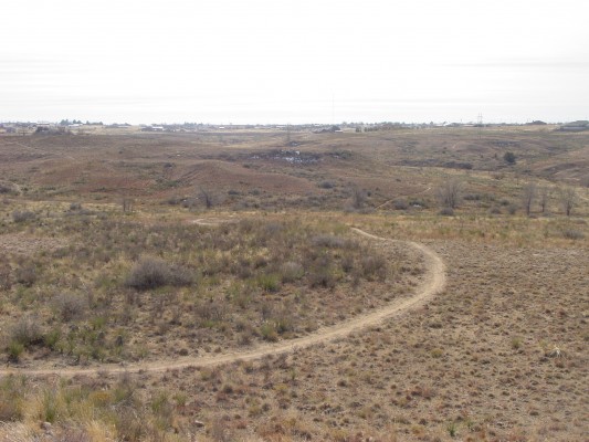
Upon our arrival in Amarillo, we first headed to a trail I discovered which was not yet in the Singletracks database, called Pitcher Pump. These trails are the product of the local Girl Scout Troop. While there was not much to recommend them going in, ya gotta like hitting a system with trail names like “Thin Mint” and “Tag-a-Long.” The various trails add up to about nine miles, all contained within an area of less than a square mile. Being mostly prairie top, you can see most of the trails from almost any vantage point within the system. There were a few deciduous trees alongside some trails, which probably makes them quite pleasing when the trees are leafed out. There were also a few ravines and an occasional rock for a slight technical obstacle–not enough to make things exciting, but much more than one would expect on the edge of Amarillo, Texas.
This ride was also accompanied by the powerful and incessant Amarillo wind. Amarillo consistently ranks in the top 5 nationally for wind, but I have lived in two other windspeed toppers: Cheyenne, WY and Great Falls, MT, so that was little deterrent. We pretty much exhausted the area in little more than a half hour, and decided it was time to move on. If only the scouts had been there hawking some of those cookies the trails are named after—that could be a real money maker!

A little over 20 miles to the Southeast of Amarillo lies Palo Duro Canyon. The magnitude and beauty of this place is nothing less than astonishing, given its location in the middle of the prairie and its apparent anonymity (how many outside of Texas have heard of the place?). In fact, Palo Duro is considered to be the second largest canyon in America after that big hole in the ground in Arizona. At only about 800 vertical feet from top to bottom, it’s not the second deepest, but it is over 60 miles long and has an average width of 6 miles with a maximum width of 20 miles–pretty impressive numbers.

Most of the canyon lies within a Texas State Park that charges $5 a person, so Miniskibum and I turned over a tenspot to the Lone Star State, and headed in, not knowing what to expect. Surprisingly, the beauty of the canyon was a match for its size. Multiple sources told me we had to hit the Rock Garden Trail, so that’s where we headed. This proved to be good advice. Over the course of about three miles, the trail climbs from the canyon floor to the canyon rim. While that makes for an easily manageable average grade, the grade was anything but consistent, alternating between super steep portions and level or even slightly downhill portions. The trail was constantly changing: up, down, left, right, buff, rough, and around every turn there was another spectacular view. It was very entertaining interval training. The canyon also sheltered us from much of the prairie winds. Once on top, we were treated to a few miles of fast, smooth prairie trail, sometimes with spooky exposure, but always with those spectacular views.

I count the Rock Garden Trail as one of those trails that actually makes a better climb than descent. All those sudden changes really kept speed in check and prevented much flow, but made for a consistently entertaining climb, despite the anaerobic stress that accompanied it. After completing this route, we had planned on hitting one of the trails on the other side of the canyon. However, there had been a winter storm a few days earlier, and we had encountered a couple brutally muddy spots in shady areas of the Rock Canyon trail, which was on the sunny side of the canyon. Fearing a lot more of this merciless red mud on the shady side of the canyon, we opted to head instead for another unknown trail, this one brand new.

About halfway from Palo Duro back to Amarillo lies the town of Canyon. On the north edge of town is the still-a-work-in-progress Buffalo Trails system. I spotted this one on a Facebook page entitled “Palo Duro Canyon Corps of Engineers.” These folks have developed a small trail system sandwiched between the city’s stadium and the freeway. This system gave me the impression of being a sort of “Pitcher Pump-Lite.” It was prairie top, back into the wind, mostly flat with a couple ravines, and you could see the whole place, which appeared to be about half the size of Pitcher Pump, from any spot in the area. The entire area was also subject to the sights and sounds of the nearby freeway.
As yet the place remains unsigned, and even finding the entrance, a nondescript gate that is part of the barbed wire fence that surrounds the place, was less than obvious. There is a proper entrance and signage in the works. Kudos to the city of Canyon for allowing the development of trails on this plot, and to The Palo Duro Canyon Corps of Engineers for making the most of it. The area’s inherent limitations will always keep this trail in the “local” category, and a minor one like that, especially with Palo Duro Canyon right down the road.

At the end of the day we were actually quite pleased with our decision to head southeast (of all places) to ride. Palo Duro, in particular, jumped into my list of special rides.

Stay tuned for part two for more mountain biking adventures in a state not usually known for mountain biking: Oklahoma.


1 Comments
Jan 2, 2014
Sounds like I'll need to spend some time on one of my drives to the Southeast checking these spots out!